
Netarhat: The Queen of Chotanagpur
A practical guide to Netarhat — the plateau’s cool hill station, its famous sunrise and sunset points, the pine and sal forests, the waterfalls nearby, and how to visit Jharkhand’s quiet highland retreat.
Netarhat is Jharkhand’s one true hill station — the “Queen of Chotanagpur”, set high on the plateau in the forested west of the state. It is a place of cool air, pine and sal woods, and long views off the escarpment, famous above all for its sunrise and sunset points, where the sun comes up or sinks over ridge after ridge of plateau. There is little to “do” in the busy sense, and that is exactly the point: Netarhat is where Jharkhandis come to slow down, and it pairs naturally with the Betla forests a few hours on.
Netarhat, in Latehar district in western Jharkhand, is the state’s cool plateau hill station — the “Queen of Chotanagpur”. Come for the famous sunrise and sunset viewpoints, the pine and sal forests, the old residential school and the waterfalls nearby (Upper Ghaghri, and Lodh, the state’s highest, further on). It’s about 150 km (4–5 hours) from Ranchi, best October to March, and pairs with the Betla tiger reserve on a Jharkhand trip.
Why visit Netarhat
Three reasons Netarhat is the plateau’s loveliest escape.
Sunrises and sunsets
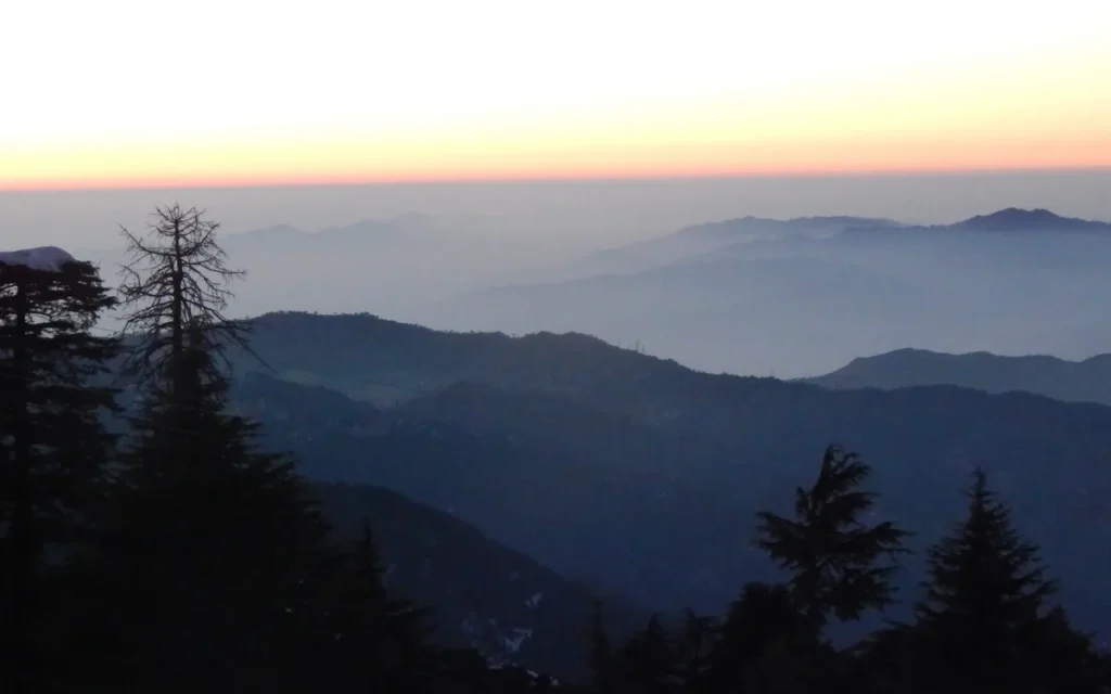
Netarhat is built around its light: the Magnolia sunset point and the Koel-view sunrise point give long, layered views over the plateau that are the whole reason to come.
Cool forest calm
At over a thousand metres, Netarhat is cool and green, wrapped in pine and sal forest — a rare highland retreat in eastern India and a genuine change of air.
Quiet and uncommercialised
This is not a built-up resort town. Netarhat stays low-key and peaceful, which is its charm — come to walk, drive the forest roads and do very little.
When to go
Netarhat is pleasant for much of the year thanks to its altitude, but the season still matters.
October to March (the season): cool, clear days and crisp mornings — the best time, with the sharpest sunrise and sunset views.
April to June: warm but still far milder than the plains, which is why it drew summer visitors; hazier views, though.
July to September (monsoon): green and atmospheric, with the waterfalls at full flow, but mist can hide the sunrises and forest roads get slippery.
Things to do in Netarhat
The viewpoints and forest are the heart of it; the waterfalls and the old school round out a day or two.
Magnolia Sunset Point
Netarhat’s famous sunset viewpoint, named for a local legend, looks west over ridge after ridge of plateau as the sun goes down. Arrive early for a spot; it’s the signature Netarhat experience.
Sunrise Point (Koel View)
The sunrise viewpoint over the Koel valley is the morning counterpart — worth the early start for the light breaking over the forested plateau.
Upper Ghaghri & Lodh Falls
The Upper Ghaghri falls are a short walk through forest near town; further out (around 60 km, near Mahuadanr) is Lodh Falls, the highest waterfall in Jharkhand at about 143 m — a worthwhile excursion in the wetter months.
Netarhat Residential School
The well-known Netarhat Vidyalaya, set in the forest, is part of the town’s identity — a scenic campus to see from outside on a drive around.
Forest drives & dams
The pine and sal forest roads, the Netarhat dam and the quiet lanes are made for aimless drives and walks — the real pleasure of a hill station that asks nothing of you.
What to eat
Food is simple and limited — eat at your hotel or the few local places, and carry supplies for day trips.
Hotel & dhaba meals
Simple North Indian meals and thalis at hotels and a handful of dhabas are the main option; there’s little in the way of a dining scene, so expect basic, hearty food.
Dhuska & litti
Jharkhand staples like dhuska and litti chokha turn up at local stalls — the tastiest cheap eats around.
Supplies for trips
For the sunrise point and the far waterfalls, carry water and snacks — options are sparse once you leave the hotels.
Plan meals ahead
Kitchens close early and choice is limited. Plan dinner at your hotel and don’t expect late-night food.
Where to stay
Netarhat has simple hotels and a Jharkhand Tourism property rather than resorts — book ahead in season.
Jharkhand Tourism hotel
The state tourism (Prabhat Vihar-style) property and a few private hotels are the main comfortable options, well placed for the viewpoints. Book ahead in the cool season and on weekends.
Guesthouses & lodges
A handful of basic guesthouses and lodges cover budget needs — plain, but fine for a night or two in a quiet hill town.
Getting there and around
From Ranchi: Netarhat is about 150 km west, roughly 4–5 hours by road through forest and plateau country — a scenic but slow drive. Ranchi’s Birsa Munda Airport is the nearest airport.
By rail: the nearest useful railheads are at Latehar and Daltonganj (Medininagar), with road transfers onward; there is no railway to Netarhat itself.
Getting around: you really need a car here — the viewpoints, waterfalls and school are spread along forest roads with little public transport. Hire a car with a driver from Ranchi or Daltonganj.
Netarhat pairs naturally with the Betla National Park and Palamau Tiger Reserve, about 100 km on — hill station and forest together make the classic western-Jharkhand leg.
A 1-day plan
A full day (and ideally a night) covers both viewpoints, the forest and a waterfall.
Sunrise, forest and sunset
Start before dawn for the Sunrise Point over the Koel valley, then spend the day on forest drives, the residential school and the Upper Ghaghri falls (or Lodh Falls if you have the time). End at Magnolia Sunset Point for the evening light.
Practical tips that actually help
Do sunrise and sunset
The viewpoints are the whole point. Make the early start for the Sunrise Point and be at Magnolia Point well before the sun goes down.
Come by car
There’s no railway and little local transport. Hire a car with a driver — ideally for the whole western leg with Betla.
Pack a warm layer
Even outside winter, Netarhat’s nights and early mornings are cool at altitude. Carry a jacket.
Book ahead
Comfortable rooms are limited and fill on weekends and in season. Reserve the tourism property or a good hotel in advance.
Carry supplies
Food and shops are sparse, especially for the far waterfalls and the sunrise point. Bring water and snacks.
Mind the monsoon mist
In the rains the sunrises can be hidden by cloud and forest roads turn slippery — lovely but unreliable for the views.
Mistakes first-time visitors make
- Coming for a single quick stop. Netarhat’s magic is sunrise and sunset. A flying daytime visit misses both — stay the night.
- Relying on public transport. The viewpoints and falls are spread along forest roads with little transport. Hire a car.
- Expecting resort-town amenities. Netarhat is deliberately low-key, with simple hotels and limited food. Plan meals and book ahead.
- Skirting the pairing with Betla. The hill station and the Palamau tiger reserve, about 100 km apart, make one natural western loop. Doing one without the other wastes the long drive out.
Planning Netarhat into a Jharkhand trip?
Netarhat and the Betla forests make the classic western-Jharkhand leg. Tell me your dates and I’ll build it into a plateau route from Ranchi.
Netarhat FAQs
Why is Netarhat called the Queen of Chotanagpur?
Netarhat earned the title “Queen of Chotanagpur” as the highest and loveliest hill station on the Chotanagpur plateau — cool, forested and famous for its sweeping sunrise and sunset views over the ridges of western Jharkhand.
What is there to do in Netarhat?
The main draws are the Magnolia Sunset Point and the Sunrise Point over the Koel valley, the pine and sal forest drives, the Upper Ghaghri falls near town and Lodh Falls (the state’s highest) further out, plus the scenic Netarhat Residential School campus.
How do you reach Netarhat?
Netarhat is about 150 km (4–5 hours) west of Ranchi by road; Ranchi’s Birsa Munda Airport is the nearest airport. The nearest railheads are Latehar and Daltonganj, with road transfers onward — there’s no railway to Netarhat itself, so most people come by car.
What is the best time to visit Netarhat?
October to March, for cool, clear weather and the sharpest sunrise and sunset views. It stays milder than the plains even in summer; the monsoon is green and full-flowing for waterfalls but mist can hide the views.
How many days do you need in Netarhat?
One full day and a night is ideal — enough for both the sunrise and sunset points, a forest drive and a waterfall. Add time if you want to reach Lodh Falls or combine it with the Betla tiger reserve.
Can you combine Netarhat with Betla National Park?
Yes — they’re about 100 km apart in western Jharkhand and make the classic hill-and-forest loop, usually done with a hired car over two or three days from Ranchi.
Related guides
Keep planning your Jharkhand trip with these:
Jharkhand Travel Guide
Waterfalls, the plateau hill station, tiger-reserve forests and the great pilgrimages — how to put a Jharkhand trip together.
Betla National Park
The Palamau tiger reserve of sal forest, elephants and jungle forts — Netarhat’s natural pairing in the west.
Netarhat sunset photo by Ujjawalagrawal2, CC BY-SA 4.0, via Wikimedia Commons; cropped and converted to WebP.
Written by Ashvinee Nagle
I travel India slowly and write it down honestly - practical guides and real itineraries from someone who lives here.
About Ashvinee →Plan your India trip with us
Get one short, honest India travel guide a week — plus a free 7-day Rajasthan itinerary to start.
Free. Unsubscribe any time.